This Information provides important considerations for properties identified as being flood prone. It is designed to assist the preparation of applications for development on properties that have been identified as being at risk of flooding. Guidance on the minimum mitigation measures that you may be required to adopt are also included to ensure your development is designed in accordance with the Planning Scheme’s Flood Prone Areas Code.
Council cannot provide design advice and it is strongly encouraged that you seek professional assistance from an appropriately qualified engineer in preparing your proposal in an area affected by river flooding.
Flood Prone Areas
Mapping of the 1 in 100 year Annual Exceedance Probability (AEP) level is available for the Kermandie River in Geeveston, Mountain River and the Huon River below Judbury and can be provided by Council’s Customer Service Officers.
Land within/below the 1 in 100 year AEP level is considered flood prone. This level represents the extent of a flood that has the probability of occurring once every one hundred years. It does not mean that flooding will only reach this level every one hundred years but that the probability of this occurring is only once every one hundred years.
There are other watercourses that are known to flood but have not had the 1 in 100 year AEP level identified. This includes Agnes Rivulet, Dover Rivulet, other parts of Kermandie River and the Franklin Foreshore. Land near these watercourses may be considered to be flood prone by the planning officer.
Development requirements
The Huon Valley Interim Planning Scheme 2015 will include a Flood Prone Areas Code (Code E.4). Planning and building applications for residential, commercial or any other habitable use in flood prone areas will need to demonstrate that risks to persons or property from flooding can be minimised to an acceptable level.
The Code seeks to ensure that:
- a building is not inadvertently built in a location or in a manner that will be damaged by floodwaters,
- natural flow paths are maintained so that the natural movement of floodwaters is not restricted, and
- waterways are not polluted by noxious uses or by on-site wastewater management systems.
If you propose new use or development you will need to demonstrate that the risk to life and property is acceptable. Relevant considerations include:
- the finished floor level of all habitable rooms is either 300mm above the known 1 in 100 year AEP (for the Huon, Mountain and Kermandie Rivers) or 600mm above the highest known flood level (your neighbours or long-term residents of the area may be able to assist you determine this),
- that there is a safe means of access to the site which typically means that the driveway and access is clear of the flood prone area,
- that the foundation design can withstand floodwaters and debris,
- that any on-site wastewater management system is not located on flood prone land,
- that the proposal will not increase the level of risk to adjoining land, and
- that any modifications to ground levels for cut and fill, access or landscaping will not have a significant effect on flood flows.
Depending of the nature of the proposal and the characteristics of the site you may need to engage an expert to prepare a flood risk report that addresses these points and other matters.
Flood Risk Mitigation Checklist
If you are considering lodging a Development Application and your property has been identified as being at risk of flooding, the following checklist may help you in ensuring the requirements of the Planning Scheme are met and therefore increases the likelihood of a timely approval.
Step 1 Identify if the site is at risk of flooding:
Please visit iplan website, Council’s website or contact Council’s Customer Service Desk to determine if your property is affected by one of the three flood overlays contained on the Planning Scheme maps.
If NO, this Information will not apply.
Step 2 Is the proposed development (building work) at risk of flooding when complete?
This can be checked by reviewing the information provided by Council to owners of properties at risk of flooding. Council can provide limited information, and for properties at risk of flooding Council may need you to provide a survey plan of the site showing the contours of the site and the finished floor level details.
The site will need to be surveyed to determine the 100 year ARI flood depth on the site flood map.
If YES, engage a qualified engineering or land surveyor to undertake a site survey.
Step 3 Prepare and submit your development application to Council. The application will need to include the following information:
Once this information is provided to Council, the nature of the development, including the extent of the proposed elevated works within the 100 year ARI flood plain will be assessed to ensure that the development will not significantly increase the 100 year ARI flood levels or risks to any other nearby property.
In assessing your application and deciding whether to grant planning approval, Council will consider whether it meets the requirements of the Flood Prone Areas Code. This information can be used in preparing a development application, if based on Council’s flood data, the development is at risk of flooding, you are strongly advised to seek professional independent engineering assistance in preparing your development application.

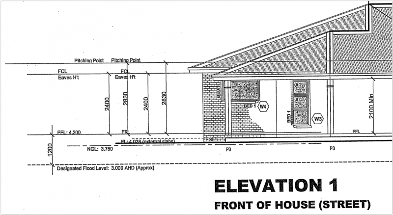
Required details on elevation plans. The elevation plan includes a survey level of the 100 year ARI and the finished floor levels.
Please Note: The information provided in this guide is only intended to be a summary. All applications are considered on their individual merits and therefore situations may vary. It is recommended that you seek independent professional advice and / or contact Council’s Planning Unit
