Landslide hazard is a source of potential harm resulting from the down slope movement of mass rock, debris or earth. Mineral Resources Tasmania has mapped the land susceptible to landslide across the State. The data provides an evidence based assessment for the susceptibility of land to risk of landslide. The coverage however is limited to major urban centres and is not available for land within the rural areas. DPAC in conjunction with MRT has applied the land susceptibility research and realised a policy and control position described in the Landslide Planning Report 2012. The maps and report provide the best available technical reference for regulatory control. The Landslide Planning Report divides landslide risk into four bands or levels of risk and establishes land use planning objectives for each band. The landslide hazard bands are shown on the Landslide Hazard Map available on Council’s GIS mapping data and the Land Information System Tasmania (The List).
The four hazard bands are summarised as follows:
Acceptable:
the risk of landslide is rare therefore there is no requirement for particular hazard management control.
Low:
the risk of landslide is possible to likely therefore warranting a precautionary approach.
Medium:
the risk of landslide is known and new use or development should be avoided. Specialist site investigation and design will be required and critical activity is prohibited.
High:
the risk of landslide is frequent or severe with all use or development consequently prohibited unless there is a compelling need.
It is important that development on steep and potentially unstable land is regulated to ensure that:
- it is located, designed and constructed to minimise the risk to human life and property,
- it is restricted, or where inappropriate, does not occur, in areas of high instability, and
- impacts on the natural environment, infrastructure and scenic amenity are minimised.
Land that is steep or is potentially unstable may be adversely affected by:
- earthworks, including excavation and fill for buildings or driveways,
- the construction of dwellings, outbuildings, retaining walls or driveways,
- on-site wastewater management systems, or
- changes to natural drainage patterns.
-
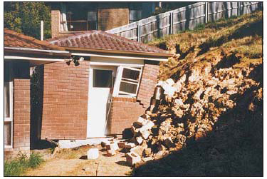
A building pushed off its foundations after a small, shallow slide caused failure of the adjacent retaining wall
Source Mineral Resources Tasmania: Landslide Brochure No. 1 – Landslides in Tasmania, 2011 www.mrt.tas.gov.au.
Is your land considered to be potentially unstable land?
Your land will be considered to be potentially unstable land if the slope exceeds the recognised threshold slope angle for the underlying geological type. On a large site this will be determined from the average slope and geological type surrounding the proposed development.
Council’s Customer Services Officers can provide advice on geological type and slope. This information can also be obtained free of charge at www.thelist.tas.gov.au.
| Geological Rock Type | Threshold Slope Angle |
| Jurassic Dolerite | 15 degrees / 27% / 1 in 4 |
| Triassic / Permian Sediments | 10 degrees / 15% / 1 in 6 |
| Tertiary Sediments | 5 degrees / 9% / 1 in 11 |
| Tertiary Basalts | 12 degrees / 21% / 1 in 5 |
| Quaternary Sediments and Talus Landforms | 7 degrees |
Planning Scheme requirements
The Landslide Code applies to all development including subdivision and habitable and vulnerable uses located in a Landslide Hazard Area. The Code aims to ensure that the landslide risk associated with buildings and works in Landslide Hazard Areas. It is important that development on steep and potentially unstable land is regulated to ensure that:
- It is located, designed and construction to minimise the risk to human life and property,
- It is restricted, or where inappropriate, does not occur in areas of high instability; and
- Impacts on the natural environment, infrastructure and scenic amenity are minimised.
Land that is steep or is potentially unstable may be adversely affected by:
- Earthworks, including excavation and fill for buildings or driveways.
- The construction of dwellings, outbuildings, retaining walls or driveways,
- On-site wastewater management systems; or
- Changes to natural drainage patterns.
Hazard management provisions have been included within the Code which address the following:
- Minor use and development, including residential use, on low level risk land is not subject to the need for hazard assessment unless for hazardous, vulnerable or critical use.
- Use is permitted if a hazard assessment indicates there is an insufficient increase in the level of risk to warrant any specific hazard reduction or protection measure.
The Code prohibits buildings and works in High Landslide Hazard Areas and all applications for buildings or works in Low / Medium Landslide Hazard Areas will be required to demonstrate that there is an acceptable risk of is capable of feasible and effective treatment through hazard management measures to form a tolerable risk. Determining the level of risk and treatment measures will usually be required to be supported with a Landslide Risk Management Report prepared by a suitably qualified civil engineer or soil scientist.
What you will need to provide if your land is considered to be potentially unstable land?
If your property is located within a Low or Medium Landslide Hazard Area it may be considered to be potentially unstable and any application to build a dwelling or other habitable structure will need to include the following:
- a statement from a suitably qualified person that describes the vulnerability of the site from land instability hazards and if necessary provides:
- a statement of the level of risk of the hazard for the site and adjoining land, including the potential consequences for life and property,
- an assessment of the impact of the proposed development (including all excavations for buildings and access, all vegetation removal and site drainage) would have on the stability of the site and adjoining properties, and
- any recommendations for the treatment of the site and the use and development that are necessary to achieve an acceptable level of risk to life and property on the subject site and adjoining land.
It is important to note that a Site and Soil Evaluation Report will not be sufficient for this purpose as a soil report only provides a classification of the soil type for footing design. The extent and detail of investigation required by the suitably qualified person will depend upon the particular site characteristics and the nature of the proposed development.
Recommendations contained in the statement from a suitably qualified person may relate to:
- preferred locations for buildings, retaining walls, driveways and on-site wastewater management systems,
- footing requirements,
- preferred excavation / retention / stabilisation techniques and suitability of excavated materials for use in on-site earthworks,
- pavement type and design,
- management of surface and sub-surface drainage, or
- vegetation retention and / or revegetation.
A suitably qualified person is typically a civil engineer or soil scientist and many are listed in the Yellow Pages under Soil Testing & Investigation or Geotechnical Engineers & Consultants. Council cannot recommend any person however you should ensure that they have local experience and hold and maintain adequate professional indemnity insurance.
In addition to landslide hazard the land may also be prone to dispersive soils. You may wish to review a separate information sheet on ‘Dispersive Soils’